Normally, when some thing or someone is loitering or lurking around your farm, it’s not usually a welcome situation, unless it’s La Niña of course, which for most producers is a bringer of rain and potential increases in profitability. New modelling indicates that there are encouraging odds La Niña will be sticking around for a 3rd season in a row.
How things can change. Not so long ago all the indications that were coming from the Australian Bureau of Meteorology (BOM) and other forecasters were that the La Niña effect that Australia has enjoyed over the past two seasons would back off this winter. This has not been the case, with indicators of a persistent La Niña state remaining throughout autumn. And predictions are that there is a good chance it could stick around sore some months ahead of that, generating solid rainfall for the east coast over the coming season.
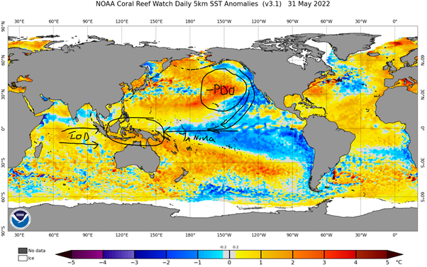
The callsigns of La Niña have continued to persist. Elevated ocean temperatures above the Australian continent in the region of southeast Asia, particularly Indonesia and New Guinea have continued to form part of the La Niña & Indian Ocean Dipole (IOD) signal. Futhermore, in the northern pacific region, water temperatures are 3-4 degrees Celsius above typical levels, indicating that the negative phase of the Pacific Decadle Oscillation (PDO) is active. The cold water down the east coast of the US associated with the negative PDO typically has the impact of reinforcing and extending La Niña effects.
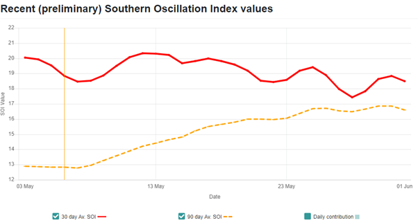
The result has been that the Southern Oscillation Index (SOI) has remained above 20, well and truly above the level of 7, which is the threshold that indicates La Niña .
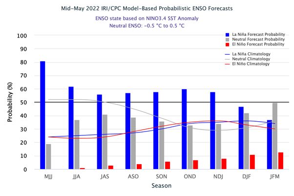
The IRI modeling group out of Colombia university has released some objective long range forecasts of the predicted El Niño Southern Oscillation (ENSO) state out as far as Q1-23 (JFM) (figure 3). What the modelling shows is that there is a predicted 60% probability of the La Niña state persisting out as far as the November to January period (NDJ on the chart), falling to around 35% by Q1-2023. Ok, 60% is not much better than a coin flip, right? However when we add a 35% plus probability of a neutral state, we are looking at a very positive forecast of a 95% chance of neutral to La Niña conditions. The chance of La Niña’s drier brother, El Niño emerging over summer are also not seen as high, at only 15%.
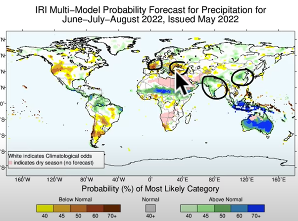
What will this mean for rainfall in practice? The answer is, for the east coast of Australia at least, it’s a good news story. IRI modelling (figure 4) indicates that we are looking forward to a 70%+ chance of above average rainfall. Looking internationally, the Indian Subcontinent will also benefit from a strong monsoon, as will rainfall over parts of southern China. However, the black sea region and Europe, particularly France will suffer from much hotter and drier summer conditions. The USA is also likely to cop a double whammy of extreme weather and hurricanes on the east coast, combined with prolonged hotter, drier conditions in the central plains wheat belt and out to the pacific north west food bowl. In all, it doesn’t look like the US drought is about to abate anytime soon, which is positive for commodity prices.
What does it mean?
New forecast modeling indicates that there is a 95% chance that a neutral to La Niña ENSO phenomenon may continue well into spring for Australia, and a 60% chance exists for an outright La Niña influence to carry on over the same period. There are also low odds of 15% that El Niño may emerge over summer 2023.
All this adds up to a positive long term outlook for precipitation over the next nine months, and potentially beyond for much of the east coast of Australia. Not so great for some other parts of the world and potentially WA, with dry conditions predicted for much of the northern hemisphere & parts of South America & southern Africa. This continued phenomena will continue to support the elevated commodity prices globally we’re experiencing now.
Have any questions or comments?
Key Points
- La Niña maintaining strength into winter
- 60% probability of La Niña being maintained until DEC-2022.
- Drier conditions in US, EU, Black Sea positive for commodity prices.
Click on figure to expand
Click on figure to expand
Click on figure to expand
Click on figure to expand
Data sources: BOM, EWMF, NAS weather


